Photo Tour: US-Mexico Border Sampler
East to west, here are a few scenes north of the United States-Mexico border. These photos are just a sampler of the trememdous variety along this stretch of more than 3000 kilometers (almost 2000 miles).
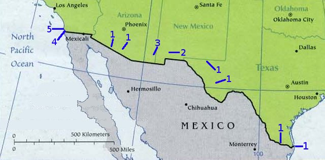
Click on one of the numbers on the map above to jump to the photo of that spot and/or a link to a page with more photos.
At the eastern end of the border -- where the Rio Grande (which is called Rio Bravo in Mexico, by the way) empties into the Gulf of Mexico, is Boca Chica Beach with this working lighthouse:
![]()
Around 150km (100 miles) upriver is the last human-powered ferry on the border. It runs between the Mexican city of Ciudad Gustavo Díaz Ordaz, Tamaulipas, and Los Ebanos, Texas. If you look closely at the photo below, you can see three men, at the far end of the ferry, pulling the rope to take the ferry to the Mexican shore in the distance.
The river is fairly narrow here. (The Rio Grande -- pronounced REE-oh GRAHN-day, Spanish for "large river" -- isn't nearly as big as rivers in wetter parts of the world.) This 1990 New York Times article has more about the ferry:
![]()
North of the area around Los Ebanos, the border region becomes much more open and less-populated. If you like art on a big scale -- Texas-sized, even (Texans like to brag that "things are big in Texas") -- take the long drive to the town of Marfa.
At a converted military base is the Chinati Foundation, a huge modern art installation spread through many buildings. This photo shows one of the many pieces by Donald Judd, Chinati's founder. In the distance are some of the buildings:
![]()
Although a lot of west Texas is fairly flat, not all of it is. One spectacular spot along the border south of Marfa is Big Bend National Park. North of Marfa, along the New Mexico state border, is an even more mountainous spot: Guadalupe Mountains National Park. The highest point in Texas, 8749 feet (2667 meters) is here. This photo shows a mountain just south of the highest one: El Capitan, 2464 meters or 8085 feet high, seen from US Highway 62/180:
![]()
Northeast of New Mexico's "panhandle" is City of Rocks. These huge rocks, standing by themselves in the middle of a valley, have been sculpted by 30 million years of wind and water:
![]()
There are more photos of City of Rocks State Park in the next page. (Follow through from the link at the end of this sampler page.)
You'll find pillars sculpted from mountains in southeast Arizona's Dragoon Mountains and the spectacular Chiricahua National Monument. Just east of the Chiricahua park boundary, and west of the village of Portal, is this view: the Cathedral Vista Point:
![]()
Spread across the border -- in both northern Sonora, Mexico and southern Arizona, U.S.A -- is the Tohono O'odham Nation. The people here (their name means "People of the Desert") were formerly known as the Papago (which means "bean eater", a name given to them by conquistadores). The new U.S. border fence cuts their land in two -- attempting to stop migrants from Mexico crossing the border illegally, but also stopping the Tohono O'odham from crossing the border legally, as they've done since before the US-Mexico border existed.
In the tribal capital, Sells (on Arizona highway 86 west of Tucson), is the Indian Oasis Intermediate School. This view is along a wall of the outdoor entryway:
![]()
The Sonoran Desert, of southern Arizona and northern Sonora, gets rain both winter and summer. This makes the desert more lush than most people expect -- especially in springtime, when you'll see wildflowers everywhere. This is basically the only place in the U.S. that you'll find saguaro cactus -- the famous cactus that grow curved "arms" (that you see in so many "western" movies, as if they grew all over the western U.S.).
Organ Pipe Cactus National Mouument is a good place to see a similar-looking cactus, the organ pipe -- which grows many more arms from its central base, narrower and usually more numerous than saguaro arms. There's a small organ pipe cactus just to the right of the center of this springtime view from the Bull Pasture Trail:
![]()
At the far western end of our border tour are two more places with Jerry Peek Photography web pages of their own: Border Field State Park, which may have a giant wall running through the middle of it by the time you see this, and the somewhat-unknown border city of Imperial Beach.
[Next page: City of Rocks State Park]
[Tour start: La Frontera: Along the US-Mexico Border]
[More photo tours]
(These photographs are Copyright © 2008 by Jerry Peek. Much higher-resolution versions of most images, and many other images too, are available at Jerry Peek Photography. Photos are available at reduced prices, or free, for non-commercial use.)